On Sunday [Damóo] morning ['abíní] we had breakfast [abínígo da'adánígíí] in the cafeteria at the Thunderbird Lodge. We again sat beneath the case of miniature rugs [diyogí] and examined and rated each one as we ate. We noted again that many of our companions were from Europe, hearing German [bééshbich'ahí bizaad] and French spoken at other tables.
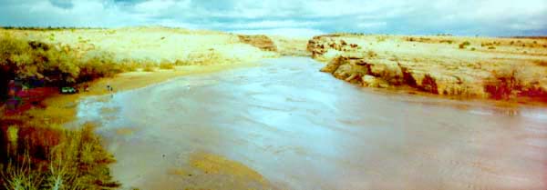
After breakfast [abínígo da'adánígíí] we made sure that our water [tó] bottles were full and our packs were ready. We then headed up the South Rim drive. At the turn to the drive a thick grove of cottonwoods [t'iis] and tamarisks [gadts'oosii] line the mouth of the canyon [bikooh]. I introduced Lori to the canyon [bikooh] slowly, stopping at each overlook along the drive, even though the canyon [bikooh] walls were just beginning to rise. The tamarisk was thick beneath the canyon [bikooh] walls here also. The view back toward Chinle (Ch'ínl9) was as spectacular as ever, with orange [[itsxo] sand dunes, pink [dinilchíí] layers dotted with green [tát['id] against the dark blue [yéego doot['izh] mesa (Black Mesa [Dzi[yíjiin]) and the incredible blue sky [yáh doot[izh]. The canyon [bikooh] itself was growing more spectacular with the gain in depth seen at each successive overlook.
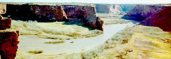
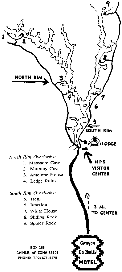
Canyon de Chelly [Tséyí'] is very different from the Grand Canyon [Tsé[ché'ékooh]. This canyon [bikooh] (a map is available.) rises from a depth of 0 ft. at its mouth just east of Chinle [Ch'ínl9] to a depth of 400 ft. at the junction of Canyon de Chelly [Tséyí'] and Canyon del Muerto ['Ane'é Tséyí' bikooh] four miles from the canyon [bikooh] mouth. By the time you reach White House Ruins, the canyon [bikooh] is 600 ft. deep. It is also quite narrow, only xx ft. wide at the ruins. When Spider Rock [Tsé'na'ashjé'ii] is reached, 22 miles from the canyon [bikooh] mouth, the canyon [bikooh] is 1000 ft. deep. The canyon walls are sandstone, with sheer drops from the top to the floor, often with no ledges at all. The erosion patterns are intricate and spectacular. There are many petroglyphs to be found throughout the canyon [bikooh] and many Anasazi ruins within, some in excellent condition. But Canyon de Chelly [Tséyí'] is also home for many Navajo families who farm the canyon [bikooh] floor, spring [daan d22go] through fall ['ak'eed] and live on the top the rest of the year. Their hooghans and cultivated fields can be seen from the overlooks. As a result, access to most of the canyon [bikooh] is limited by agreement between the National Park Service and the Diné. There is one hike permitted from the canyon [bikooh] rim to the floor without need to hire a Navajo guide: to White House Ruins. Lori and I took this hike, down through the ages of the sandstone walls, 600 ft. to the canyon [bikooh] floor.
We started down the trail, first passing through a tunnel chipped into the stone. The Chinle formation is a thin top layer here, when present at all; the maroon [di[hi[go [chíí] Shinarump conglomerate is passed through next and is very distinctive. The major part of the drop is through the highly structured de Chelly sandstone.
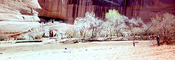
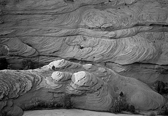
It takes very little time to walk down to the canyon [bikooh] floor. We stopped many times to look at the patterns from the fossil sand [séi] dunes, still seen in the crossbedded de Chelly sandstone. After walking through another tunnel through the stone, we emerged next to a fenced yard or field and turned toward the river [tó dahní[ínígíí] through a grove of tamarisk [gadts'oosii] trees. We still dropped a bit more through the loose sand [séi] on the canyon [bikooh] floor and then walked along the river [tó dahní[ínígíí] about 1/4 mile beneath the canyon [bikooh] walls to the site of White House Ruins on the other side of the river [tó dahní[ínígíí]. While it was quite cold (we were at ~5000' on the floor of the canyon [bikooh]) the river [tó dahní[ínígíí] was still moving quite rapidly under a thin sheet of ice [tin]. Crossing could be difficult. When we reached the point directly across from the ruins, the canyon [bikooh] had opened out a bit. There was a grove of cottonwoods [t'iis] on both sides of the river [tó dahní[ínígíí]. Several children ['á[chíní] were playing on a small dam that had been constructed from cottonwood [t'iis] branches. This dam provided a way to traverse the river [tó dahní[ínígíí] for the surefooted.
As I had been here so many times before that I had literally lost count, I found a place to sit among the cottonwoods [t'iis] where I could enjoy the solitude and silence and read the poetry books I had carried down. The only sounds were the gurgling of the water [tó] beneath the ice [tin], the rattling of the dry leaves remaining on the cottonwoods [t'iis] in the slight breeze[]ch'i], the calls of ravens [zhí'ii], and an occasional call from one of the children ['á[chíní]. Lori crossed the river [tó dahní[ínígíí] and wandered through the cottonwoods [t'iis] surrounding the ruins on the other side of the river [tó dahní[ínígíí].
Examine a selection of posters of Ansel Adams photographs.
The buildings here were built on two levels, one set of buildings on ground level at the base of the cliff and another set in a large alcove in the canyon wall, 35 ft. above the canyon [bikooh] floor. The ground level buildings have only partial walls remaining standing because they are completely exposed to the weather [t'áá ákwííj9 ní[ch'ih 'a['22h 'ánáání[ígíí] and the river [tó dahní[ínígíí]. The upper level buildings, in the alcove, are well preserved. It is from these buildings that the name White House Ruins derives. The white [[igai] washed outer surface of some of these buildings is still intact, although you can read (with binoculars) the names and dates carved into the buildings by the "discoverers" and early visitors last century and early this century before the site was protected. Graffiti is by no means a modern invention, as sites like Newspaper Rock and El Morro attest. The urge to say "Kilroy was here" appears to be universal.
![]()
I had packed my binoculars along in with the poetry books. Therefore I was able to watch the ravens [zhí'ii] play in the air currents. They would glide along the face of the canyon [bikooh] walls, almost touching the wall with their wings, as if they were playing tag with their shadows. The wing tips (physical and shadow) would approach each other and then separate again. They would do this again and again, obviously having fun. While I read, watched the ravens [zhí'ii], and just reveled in the unbelievable luck of being here again, Lori walked among the cottonwoods [t'iis], listening to the leaves rustle in the breeze []ch'i]. She talked with the Navajo man selling jewelry [íl98go naalyéhé] there. One of the children ['á[chíní] was his, but the others were already playing here when he arrived. The children ['á[chíní] played together naturally in a compatible play group, the older taking responsibility for the younger ones, taking the canyon [bikooh] and the river [tó dahní[ínígíí] as their playground. Lori had taken a small set of 4 or 5 leaves [at'22'] (branch tip included) as a rattle to remind her of the sound of the breeze []ch'i] through the dry leaves [at'22']. After an hour or so we met and decided that it was time to begin the hike back up to the top. As we walked along the canyon [bikooh] walls, we tapped them and found that, in many places, what we saw was a thin layer which would completely separate at some time in the future, showing a new face to the world. This process is called exfoliation. Almost half of the places we tapped gave back a hollow sound. All the sand [séi] under our feet was once a part of the canyon [bikooh] walls here or somewhere upstream.
After walking back to the trail and through the grove of trees to the base of the sandstone, we entered the tunnel and started up. It took a lot longer to climb back up than it did to drop down. We took many breaks to admire the fine structure in the sandstone and to make use of our water [tó] bottles. When we made it to the top, we walked over to the Park Service overlook to see where we had been. It was definitely a different view from up here with some spectacular erosion patterns visible best from above.
It is certainly more pleasant down there and well worth the effort to make the hike. I have probably made the hike 20 times or more since I first walked down in 1979. I can't say it is new each time, but it is always more beautiful [hózhóní] than I remember it to be. I always notice something that I hadn't seen before. The light changes; the breeze []ch'i] plays with my skin [akágí]; it is certainly like no other place I have ever been.
We then continued out the South Rim drive to the rest of the overlooks. At Spider Rock [Tsé'na'ashjé'ii] the canyon [bikooh] is much narrower and deeper. Spider Rock [Tsé'na'ashjé'ii] itself is a sandstone monolith that reaches up from the canyon [bikooh] floor, just beyond the overlook at the junction of Canyon de Chelly [Tséyi'] and Monument Canyon. From the same area you are able to look to the west down the arm of Canyon de Chelly [Tséyi'] with a narrow winding stream beginning to build toward the river [tó dahní[ínígíí] that will emerge from the mouth of the canyon [bikooh].
The paved road ['atiin] ends at the turnoff to Spider Rock [Tsé'na'ashjé'ii] overlook, but the road ['atiin] continues across the Defiance plateau. By following this road ['atiin] for a couple of miles, we found a crude sign indicating that the side road ['atiin] would lead us to Three Turkey Ruins. Steve and I had been there over a decade ago. Three Turkey Ruins is a Navajo Tribal Park on a canyon [bikooh] rim across from an almost perfectly preserved set of "ruins" with a group of three upside down turkeys [t2zhii] carved into the back wall of the alcove in the canyon [bikooh] wall which protects the buildings.We took the turn and drove down another graded dirt road ['atiin] which turned back to run approximately parallel to the south rim road ['atiin]. The road ['atiin] crossed the stream through Three Turkey Canyon and rose to the level of the rim. We passed only one side road ['atiin] that looked like it might lead to an overlook or to somewhere other than an isolated residence. We drove past the unmarked road ['atiin] and on for a couple of miles but found no other possible road ['atiin]. We were headed toward Nazlini [Nazlíní] from the other side! We turned back and went up the only possible road ['atiin]. This road ['atiin] was little more than a two track path through the sagebrush [ts'ah] and was very eroded in places. I had to drive very carefully and straddle deep gulleys. After about a mile, when we could see no progress toward our goal and, finding ourselves in a small traffic jam (three other cars [chidí]), we concluded that we couldn't be on the right road ['atiin] and were instead risking intrusion on a local gathering (we had gotten some strange looks from the occupants of the other cars! [chidí]). We found a place to turn around, carefully made our way out, and returned to the south rim road ['atiin] and back to Chinle [Ch'íníl9 ], disappointed. We were reluctant to stop at any of the residences, each set well back from the road ['atiin], because we did not want to impose on the local Navajos and weren't sure that we would be welcome. [Until quite recently, the Navajo did not live in towns, but were dispersed in small family groups across the landscape. Many Navajos still choose to live in relative isolation with their nearest neighbor several miles away. The population density on the Rez is ~6 persons/square mile.]
Thwarted in our desire to see Three Turkey Ruins, we decided to see the North Rim overlooks this afternoon ['a[ní'ní'3dóó bík'ij8'], instead of in the morning, ['abíní] as planned. This would leave us more time tomorrow [yisk32go] for other excursions before our drive to Gallup [Na'nízhoozhí]. We were thwarted again at Ledge Ruin since that road ['atiin] was closed, but we went on to the Antelope House overlook. Here we could see ruins of a large structure built on the canyon [bikooh] floor at the base of a sandstone wall. You can still see, even when there is no structure remaining above the ground, circular and rectangular outlines on the ground where floods from the river [tó dahní[ínígíí] have washed the buildings away. The name for this site is derived from the excellent paintings of antelope [jádí] on the canyon [bikooh] wall, high above and to the left of the buildings. These paintings are attributed to a highly respected Navajo artist, Dibé Yázhí (Little Sheep), who lived here in the 1830's. Mixed in with these paintings are petroglyphs made by the previous inhabitants of these buildings. This area is also occupied at the present time by Navajos who cultivate the wide level areas with beans [naa'o[í], corn [naad99'] and squash [naayízí]. From this overlook, we could also see the tomb of the Weaver and Navajo Fortress.
From here we drove on to the Mummy Cave and Massacre Cave overlooks. We stopped first at Massacre Cave, the site of a bloody battle between the Spanish and the Navajo in 1805. The accounts of the Spanish and the Navajo differ greatly on this battle. The Spanish reported that they killed 115 Navajo and took 33 captives. The Navajo version of the story places most of the men [hastóíí] away hunting in the Lukachukai (Lók'aach'égai) Mountains. When the old men [hastíínsání] and women [sáanii] spotted the raiding party, they took refuge in what is now known as Massacre Cave, high up in the 1000 ft canyon [bikooh] wall and inaccessible from above. The Spaniards located them from the rim where we stood. There are still marks on the walls of the cave left by richochetting rifle bullets. Some of the Spaniards made the hard climb up from below. In one of the hand to hand battles which followed, a Navajo woman [asdzání] pushed a Spanish soldier backwards off the ledge and fell with him to death on the rocks [tsé] below.
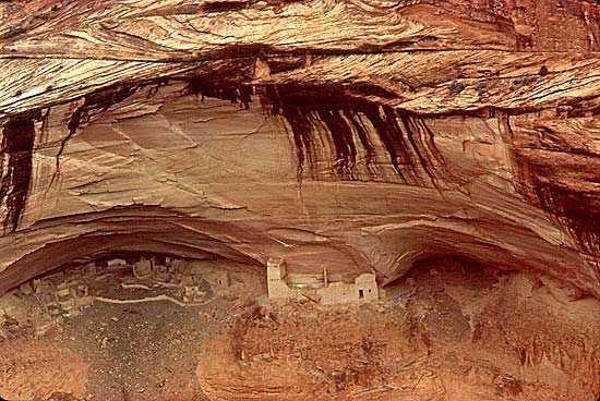
One of the most beautiful ruin sites is Mummy Cave, where we next went. This site shows evidence of continuous habitation from about AD 300 to 1300. The buildings are found in two adjacent caves several hundred feet above the stream bed. The largest and most accessible of the ruins are found in the eastern cave, with 50 ['ashdladiin] rooms and 3 [táá'] kivas. The western cave contains only about 20 [naadiin] rooms and is presently accessible only via a narrow ledge directly from the eastern cave. On the central ledge, seven [tsosts'id] rooms are found, including a 3 [táá'] story tower which was built after the rooms in the two [naaki] caves, perhaps by people who had left the Mesa Verde region. The tower structure was built at about AD 1285. Throughout these buildings much of the original plaster remains on the inner and outer walls, showing varied colors and painted designs. Mummy Cave received its name because two [naaki] well preserved mummies were found in sites below the buildings in the talus slope during the 1880's. The leader the expedition is credited with naming the canyon Canyon del Muerto ['Ane'é Tséyi' bikooh] or Canyon of the Dead following the discovery of these mummies. I find the name to be more appropriate in memory of the victims of the 1805 massacre at the site we had visited just before.
The canyon floor is extremely beautiful from these overlooks well up the canyon [bikooh] arms. The floor is not wide and flat is it is nearer the canyon [bikooh] mouth, but has a small stream cutting through steeply sloping soft ground [[eezh] in a narrow space between vertical sandstone walls. Cottonwoods [t'iis] are sprinkled near the stream and flocks of sheep [dibé] can sometimes be heard far below.
The canyon walls [bikooh] are sprinkled with numerous (~800
[tseebíidi neeznádiin]) other sites where buildings, as small as
grain storage cribs, or larger habitations, can be seen. By looking
carefully, we saw many. However we would
arrive in Gallup [Na'nízhoozhí] tomorrow evening, and Lori must work on her job application.
Therefore we terminated the touring for the day [j9], filled our gas tank [chidí bitoo dahsi'ánígíí] with gasoline
[chidí bitoo', or stew [bitoo'] for the car] back at our
favorite station [chidí bitoo bá'a'íí'áhí].
We asked after the young Navajo boy ['askii] who was in the hospital [azee 'al'3[] and found
that he was doing much better. We then returned to the Thunderbird lodge for dinner,
a last review of the miniature rugs [diyogí],
a night of reading for me and writing for Lori.
 New! Tséyi'/Deep in the Rock: Reflections on Canyon De Chelly,
Laura Tohe and Stephen Strom (photographer), Univ. Arizona Press.
Recommend this website to a friend!
Navajo Spaceships, Star Mountain and Rez Memories, An Online Writing Journal, Prose & Poetry by John Rustywire, Navajo
Antelope House Tours a Navajo owned business offering 4 x 4, horseback and hiking tours of Canyon de Chelly, including overnight stays in the canyon.
A page with information on satellite images of this area is also available.
Approximately a dozen photographs of Canyon de Chelly can be found in the Special Collections and Archives Department, Cline Library, Northern Arizona University.
Subscribe to American Indian Art Magazine
Arizona Highways
References
Books on Navajo Rug Weaving
Music & Videos
Visit The Sonoran Desert 5000 square miles of silence.
Return to the Roxanne Swentzell page

