 De-Na-Zin Wilderness Area
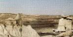
Millions of years ago this region was part of a semi-tropical environment
where abundant vegetation and reptilian creatures thrived. Only
remnants of this past plant and animal life exist. Over the eons,
the climate, plant and animal life changed. Today the area lies in
the high desert region of the Colorado plateau in the San Juan
Basin, where the harsh arid environment has resisted efforts to
tame its uncivilized nature.
In the recent past, legend has it that large flocks of cranes set
down in the area to rest and feed before continuing their migratory
flight. Thus, the area received the name De-na-zin (Day-naa-zin)
which means "standing crane" in the Navajo language.
The area is now known as the De-Na-Zin Wilderness, designated by
Congress in the San Juan Basin Wilderness Protection Actof 1984.
This 24,000 acre unit is part of the National Wilderness
Preservation System.
Plant Life
Because of changes in elevation and a diversity of terrain, five
habitat sites are found in the De-Na-Zin. An upland
piñon-juniper community and sagebrush flat in the eastern
portion of the wilderness contains yucca, Mormon tea, snakeweed,
assorted grasses, cacti, and sagebrush, as well as piñon and
juniper trees. Sloping down towards the west, sandy washes cut
through the badlands. These areas produce very little vegetation,
due in part to poor soil conditions and low rainfall. Rolling
grasslands towards the south consist primarily of Indian ricegrass
and alkali sacaton. Interspersed throughout the southwest and
northern portions of the wilderness are sandstone-capped mesas
and one area that contains a remnant population of pondorosa pine
trees.
Natural History
The colorful scenery of the De-Na-zin has been produced by the
weathering of three geological formations: the Kirtland Shale, the
Ojo Alamo Sandstone, and the Nacimiento Formation. Natural forces
have slowly eroded these formations into interesting land forms.
The Kirtland contains shales and alternating layers of sandstone
that make up the scenic badlands and mesa tops in western De-na-zin.
Exposure of the Ojo Alamo and Nacimiento results in beautiful rust,
grey, red, black and white colored caps of mesas at the head of
De-na-zin wash.
During the Upper Cretaceous and Early Tertiary periods (approximately
70 million years ago),
this region was populated by many large reptiles and a few
primitive mammals. one theory holds that the earth was undergoing a
major transition, from being a reptilian-dominated world to one
dominated by mammals. Evidence of this region's past can now be
found throughout the badlands in the form of numerous petrified
logs, dinosaur bones, mammal fossils, and other plant and animal
fossils.
Federal law prohibits the collection of any fossil resources.
Collection of petrified wood and other
fossil material interferes with scientific research and eliminates the
opportunity for others to view, sketch, and photograph these unique
features of the wilderness.
Wildlife
The wildlife of De-na-zin varies with the changes in terrain and
vegetation. few species of animal life inhabit the badlands, except
for lizards and snakes including the prairie rattler. In contrast,
the grasslands and piñon-juniper communities are home to
birds and mammals such as jays, ravens, quail, doves, rabbits,
badgers, and coyotes. Ferruginous hawks, prairie falcons, and
golden eagles may also be observed soaring overhead.
Remember, the wilderness is home for these birds and animals and
you are the visitor.
Wilderness Management
The Bureau of Land Management (BLM)
is directed to manage the De-na-zin Wilderness in a way that preserves its
wilderness values for the long term. Preserving these values involves protecting the
area's natural qualities, outstanding opportunities for solitude and primitive types
of recreation, and the area's special features. Wilderness must
be used in ways that will leave it unimpaired for the use and
enjoyment of future generations. Some uses that do not seem
compatible with wilderness preservation, such as certain types of
mineral operations and livestock grazing, are allowed to continue
under the Wilderness Act of 1964. The BLM strives to emphasize uses that
preserve the wilderness as a place people can visit and enjoy in its
natural state.
Managing wilderness is a difficult task that requires a commitment from
the managing agency as well as the public. The challenge for managers
lies in overseeing the use of other resources and activities
within the wilderness in a manner that is compatible with the
wilderness resource. The challenge for visitors is to use the area in
harmony with the wilderness environment.
The De-na-zin Wilderness Management Plan (1989) contains specific
administrative guidance for preserving wilderness values. It also
details actions to restore any natural conditions negatively affected by
human influencesm, and to allow the area to be nurtured and preserved as
wilderness. The Management Plan is available from the Farmington office
of the BLM upon request.
No permit is required at this time to visit the De-na-zin Wilderness.
Permits are required for most uses other than primitive recreation.
including grazing, mineral exploration, scientific research,
outfitting/guiding, and commercial filming.
Efforts are continuing to acquire the private inholding and resolve
an unauthorized occupancy. Consolidation of public ownership within
wilderness is perceived as essential for effective wilderness
management.
One vehicle route has been granted for private landowner access
within the wilderness. This route is the minimum necessary for the
use and enjoyment of this private land and the protection of
wilderness values.
Travel Tips
There are no services or conveniences near the wilderness. Stock up
on supplies and gas before your visit.
- Bring plenty of water - no drinking water is available.
- Firewood is not available - a portable stove is helpful.
- Bring clothing for extremes in day and night temperature.
- Tell a friend where you will be and for how long.
- Boots, sunglasses, first-aid kit and sunscreen are useful.
Wilderness Etiquette
- Pack out what you bring in.
- Enjoy natural objects but leave them for others.
- Walk softly, leave no trace.
Public Access
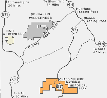
The De-na-zin Wilderness is accessible from Farmington or Crownpoint, New Mexico
via State Highway 371 to County Road 7500 (formally CR 15), then
travelling east to the wilderness entrance.
Visitors can also get there from Bloomfield or Cuba, NM via State
Highway 544 (formerly 44) to County Road 7500 at the Huerfano
Trading Post, then travelling west to the wilderness entrance.
Travel on the county road is good during
dry conditions but the road can get slippery and rutted during the wet
season, normally in spring and late summer.
A short dirt road connects the county road and parking area at the
wilderness boundary.
Topographic Coverage
Alamo Mesa West, Alamo Mesa East, and Huerfano Trading Post SW,
NM.
Visitor Opportunities
The wilderness is open all year. Visitors can expect to find an
experience of solitude in the De-na-zin. Most visitors visit the
upland rolling grasslands and sagebrush flats near County Road 7500
in eastern De-na-zin, enjoying the wilderness from a distance. When
the sun is low in the sky, a wonderfully colorful view of the
landscape unfolds.
Those who hike into the badlands along sand washes and into the
backcountry have the opportunity to achieve a strong sense of
solitude and isolation from the sights and sounds of civilization.
There is a good probability of experiencing minimum contact with
others, independence, closeness to nature, self-reliance through
the application of backcountry skills, and an environment that
offers a high degree of challenge and personal risk.
Highway directional signs, a rustic parking area near County Road
7500, interpretive displays, and a self-issue registration are
planned. no other recreational developments such as trails,
signing, or camp sites are planned. Visitors are left to explore
and discover the wilds of the De-na-zin without management controls
that may intrude upon the wilderness experience.
The wilderness contains inholdings with private residences, a
vehicle trail to these inholdings, livestock grazing, and mineral
development. In some areas of the wilderness, these activities
might be observed. The BLM will controll their obtrusiveness to the
maximum extent allowed by law, to preserve wilderness character.
Volunteers
The Bureau of Land Management wishes to recognize the important
contribution to public land management made by wilderness volunteers.
They have completed numerous projects and provided an important presence
in the field while doing projects they enjoy. The BLM invites anyone
interested in wilderness management to join the volunteer efforts.
For further information contact:
Bureau of Land Management
Farmington Resource Area Office
1235 La Plata Highway
Farmington, New Mexico 87401
(505) 327-5344
or
Farmington Convention and Visitors Bureau
203 W. Main - Suite 401
Farmington, New Mexico 87401
In State (505) 316-7602
Out of State 1-800-448-1240
This page is essentially a copy of the public domain pamphlet on the
De-Na-Zin Wilderness provided by the BLM.

References
- Navajo Sacred Places, Klara Bonsack Kelley, Harris Francis, Indiana Univ Press.
- Native Roads : The Complete Motoring Guide to the Navajo and Hopi Nations,
- Fran Kosik, George Hardeen, Creative Solutions Pub.
- Named in Stone and Sky : An Arizona Anthology, Gregory McNamee (Editor),
- Univ of Arizona Press.
- Talking to the Ground : One Family's Journey on Horseback Across the Sacred Land of the Navajo
- Douglas Preston, Univ of New Mexico Press.
- A Guide Book to Highway 66, Jack D. Rittenhouse, Univ of New Mexico Press.
- Basin and Range, John McPhee, Noonday Press.
- Navajo Country : A Geology and Natural History of the Four Corners Region, Donald Baars, Univ. New Mexico Press.
- The Colorado Plateau : A Geologic History, Donald L. Baars, Univ of New Mexico Press.
- Roadside Geology of Arizona, Halka Chronic, Mountain Press.
Return to Day 8