 Bisti Wilderness Area
  Bisti Wilderness Area
 As the inland seas retreated to the north, the coastal swamps and succeeding forest parks and meadowlands of northwest New Mexico disappeared under the advancing river flood plains. Within these sediments lie the buried remains of the rich animal life that lived there. Ancient animal life is represented by isolated teeth and bones of fish, turtles, lizards, mammals, and dinosaurs, who at their zenith dominated the other life forms. These treasures of the past await explorers willing to brave this badlands wilderness.
This 3946 acre area is now known as the Bisti Wilderness. It was designated by Congress in the San Juan Basin Wilderness Protection Act of 1984. Bisti, translated from the Navajo language, means "badlands" and is commonly pronounced (Bis-tie) in English and (Bis-ta-hi) in the Navajo language.
Federal law prohibits the collection of vertebrate fossils and petrified wood without authorization. Collection of petrified wood and other fossil material interferes with scientific research and eliminates the opportunity for others to view and to photograph these unusual wilderness features.
The abundant vegetation and animal life that once existed is in stark contrast to today's barren badlands. time and the natural elements have etched out a fantasy world of strange rock formations and fossils. It is an ever changing environment that offers the visitor a remote wilderness experience.
The two major geological formations found in the wilderness are the Fruitland Formation and the Kirtland Shale. The Fruitland Formation makes up most of what the visitor will see while in the badlands and contains interbedded sandstone, shale, mudstone, silt and lignite to bituminous coal. The weathering of the sandstone forms the many spires and hoodoos (sculpted rock) found throughout the wilderness. The Kirtland Shale contains rock of various colors. This shale caps the mushroom shapes landforms of the area. The red hills result when the shale is baked by high temperatures produced by oxidation of the surrounding coals. These hills are most picturesque at dusk. The billowy mounds made up of a crumbling layer of caked soil are the product of rapidly eroded silts and clays.
Climbing on rock formations is dangerous, accelerates erosion and destroys the scenic value of the area.
Managing wilderness is a difficult task that requires a commitment from the managing agency as well as the public. The challenge for management lies in ensuring that the management actions and activities within the wilderness are carried out in a manner that is compatible with the wilderness resource. The challenge for visitors is to use the area in harmony with the wilderness environment and to leave no trace of your visit.
The Bisti Wilderness Management Plan (1986) details specific administrative guidance for preserving wilderness values. It also details actions to restore any natural conditions negatively affected by human influences, and to allow the area to be nurtured and preserved as wilderness. The Management Plan is available from the Farmington office of the BLM upon request.
No permit is required at this time to visit the Bisti Wilderness and to engage in primitive types of recreation. permits are required for uses such as grazing, mineral exploration, scientific research, outfitting/guiding, and commercial filming.
The Bisti Wilderness Management plan call for replacement of highway directional signs and maintenance of an undeveloped parking area, boundary fencing and signing. Development of interpretative displays and a self-registration system are planned actions as well as acquistion of an adjacent section of state land once the Gateway Coal Mine has been reclaimed.

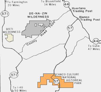
The Bisti is accessible from Farmington, New Mexico, by traveling south on State Highway 371 for approximately 30 miles and exiting left for six miles on a gravel road that will take you past the old Bisti Trading Post to an undeveloped parking area and access to the wilderness. The area can also be approached from Crownpoint, New Mexico, by traveling north on State Highway 371 for about 46 miles and following the same gravel road described above. Travel on the gravel road is good during dry conditions but the road can get slippery and rutted during the rainy season, normally in spring and late summer.
Use of this area is regulated only to the extent necessary for its protection and your safety.
Exploring the many carved out enclaves leading from the washes allows visitors the opportunity to experience solitude and a primitive type of recreation. The highly erosive soils often erase the footprints of others that came before and may give the sense of isolation in a foreign land. The landscape has been described as a moonscape where your imagination and artistic talents could run wild.

References
 |
 |