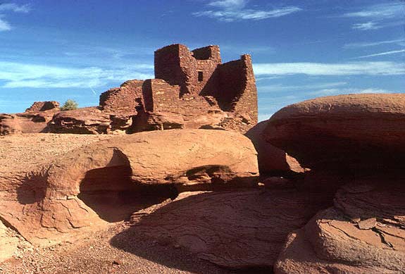
The prehistoric Sinuguan and Anasazi dwellings at Wupatki were long abandoned when Captain Lorenzo Sitgreaves arrived in 1851. Sitgreaves was looking for an overland transportation route through the recently acquired New Mexico territory, a mission that brought him to the Colorado Plateau with its ancient treasures. His was the first European-American documentation of these ruins, built by the ancestors of the modern Pueblo Indians of the Southwest. Others followed Sitgreaves, notably John Wesley Powell. The Civil War soldier-turned-geologist in 1869 became the first in historical times to navigate his way down the Colorado River through the Grand Canyon. In 1885, as head of the U.S. Geological Survey, Powell explored the San Francisco volcanic field. One bright rimmed cone particularly impressed him. "The contrast in the colors is so great," he wrote in his journal, "that on viewing the mountain from a distance the red cinders seem to be on fire. From this circumstance the cone has been named Sunset Peak."
As the era of exploration drew to a close and the era of scientific advancement took hold, both sites enjoyed scrutiny by a number of interested people. Around the turn of the century archaeologist Jesse W. Fewkes carefully mapped and photographed the Wupatki area, using appropriate Hopi terms to label cultural and geographic phenomena. But no one offered substantial evidence that Wupatki might be in any way connected with Powell's "Sunset Peak" until archaeologists began excavations. Twentieth century scientists did not have to guess the age of the artifacts they unearthed; modern techniques allowed them to accurately place their material findings within the time frame of the Southwest. A major breakthrough for archaeologists and geologists alike came in the 1930s with the refinement of dendrochronology, or tree-ring dating. This process matches the pattern of growth rings from a tree of an unknown date with patterns from a cross-section of a tree of the same species whose age has been established. Because new rings are produced annually, this method can date timbers to the year they were cut. Many of the ruins - the ash-covered pithouses near Sunset Crater as well as the Wupatki pueblos - had timbers as roof beams or structural supports. Researchers noted the ring patterns. They compared pottery sherds found in pueblo rooms and prehistoric trash dumps with known types of earthenware. In the 1960s, through paleomagnetic dating, geologists determined the directional alignment of iron particles in the solidified lava flows, then precisely measured the deviation from today's magnetic north to yield the number of years since the particles were set in their present configuration. Piece by piece like a jigsaw puzzle, they constructed a picture of an ancient farming people who fled when a volcanic cone emerged from their cornfields, and who returned to the area along with other Indian groups to build settlements and exchange goods and ideas.
Research continues. An archaeological site survey completed in 1987 answered some questions and raised many more. We know, for example, that the prehistoric people left the area permanently within 200 years of the eruption of Sunset Crater, but why did they leave? Perhaps it was because of drought, disease, overpopulation, or a combination of all these things. Perhaps it was something entirely different. And where did they go? We know the date of the most recent volcanic explosion, but when and where will be the next birth of a volcano?

The peoples living northeast of what is now Flagstaff, Arizona, in the winter of AD 1064-65 must have been warned by rumbling and shaking earth before debris exploded out of the ground and rained down on their pithouses in much the same manner that the cindercone Paricutin burst into existence in a Mexican cornfield nine centuries later. These Indians, now called the Sinagua (Spanish for "without water"), were forced to vacate the rocky land they had cultivated for 400 years.
Lava flows and several feet of cinders and rock obliterated their old farmland in the immediate vicinity of Sunset Crater. but just a few decades after the eruption, the Sinagua discovered that they could grow crops in previously uncultivated terrain. Not far north of the cone, a combination of forces was at work: a thin ash layer from the volcano absorbed precious moisture, helped prevent evaporation and conserved heat, slightly lenghtening the growing season. And, evidence suggests, a change in climate made water more plentiful. Some of the Sinagua - along with Kayenta Anasazi from the northeast and Cohonina from the west - migrated to the Wupatki area. Southwestern peoples had long been trading among themselves. Now three diverse groups advanced as never before by sharing their technology and participating in social activities. Whether it was because of disease, dispersal of the life-producing ash cover, depletion of natural resources, or an extensive drought beginning in 1150, Wupatki's mosaic of cultures had disbanded by about 1225. Small groups of Sinagua and Anasazi scattered in different directions. And the Wupatki pueblos would never again shelter permanent residents.
The Sinagua homes at Wupatki ranged in size from single story, single family houses to a multi-level "high-rise" pueblo, the largest dwelling in the area, which probably contained more than a hundred rooms.
When the Sinagua moved to the Wupatki basin in the early 12th century, they found the native materials ideal for construction of freestanding masonry dwellings. Slabs of sandstone, limestone and basalt with a clay based mortar yielded sturdy buildings that, despite weathering and vandalism, remain partially intact more than 700 years after their owners departed.
Masonry ballcourts such as those found at Wupatki are usually found much farther south.
At least 125 different types of pottery have been found within the monument, suggesting a rich culture during Wupatki's heyday.
An amphitheater, about 50 feet in diameter, most likely served as a ceremonial gathering place for the Sinagua of the Wupatki pueblo.
Species Lists for Wupatki National Monument are available from the National Park Service.