The mudhill landscape is formed out of the colorful beds of fine mudstone, claystone, decomposed volcanic ash (bentonite), limy mudstone (marl), and conglomerates of the Chinle Formation. The surfaces of these bentonite layers rise and swell with every rain and then shrink as they dry to a cracked, powdery crust. I have walked over these mudhills when the surface crumbled to powder beneath my feet. I have walked over these mudhills after a rain carrying a layer of mud six or more inches deep on the soles of my shoes. The road through this region becomes a slippery, sometimes elevated, track from which you may easily slide off if you lose control of your car. This surface instability and the high gypsum content of the material makes it difficult for vegetation to become established, and this further enhances the erosion.
The surfaces of the flatter regions between mudhills are covered with pebbles and rocks that have been washed out of the Chinle Formation. While some of these stones are prosaic items eroded from the Shinarump Conglomerate, which overlies the Chinle, most are pieces of petrified wood in sizes from small pebbles to substantial logs. These colorful stones originate from logs which were washed downstream in ancient floods and buried in stream sediments and volcanic ash. The volcanic ash is composed of tiny particles of bubbly silica glass. It is the high content of volcanic ash in the Chinle Formation that made the preservation of these trees possible. The groundwater dissolved the silica until it became saturated. This silica solution was absorbed into the cellulose structure of the wood where it slowly replaced the decaying organic material and solidified into the variagiated tree shaped stones thet we find today.
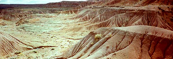
The Navajos refer to this valley as Beautiful Valley.
Other "badlands" regions on the Navajo reservation can be found near Tuba City where pinks are the predominant colors, south of the Hopi buttes (The Little Painted Desert) where greens and grays predominate, and along US 89 from Cameron to Page where grays reign.

References
© 1994 Karen M. Strom
Return to Day 2