The Devils Tower site was the first site designated as a National Monument, in 1906. The top of the tower is at an altitude of 5,117 feet, 600 feet above the base of the tower and 1,270 feet above the level of the Belle Fourche River. The diameter of the tower, at the base, is about 800 feet. The top of the tower is almost flat. It's dimensions are approximately 180 feet along an east - west line and 300 feet along a north - south line.
Devils Tower is formed of igneous rocks that have intruded through the sedimentary rocks that form the local landscape. The most striking feature of the tower is the polygonal columns of rock that form the mass of the tower. Most of the columns have 5 sides, but some have either 4 or 6 sides. The larger columns have diameters of 6 to 8 feet at the base of the column and taper to diameters of about 4 feet near the top of the tower. The sides of the columns are smooth joints near the base but may become wavy and some of the columns may unite as they rise up the tower. There are numerous cross-fractures in the upper part of the tower creating many small irregularly shaped blocks from the well organized columns. The columns are almost vertical in the upper part of the tower but flare out at the tower base.
The columnar joints were formed as a consequence of the contraction of the rock mass as it cooled. When a rupture takes place, during the cooling, three fractures radiate out from a point. In an ideal situation, each angle formed would be 120°, (360° / 3). Then, if the fracture points were evenly distributed, a set of uniform hexagonal (6 sided) columns would be formed. These ideal conditions are never found in nature; therefore a distribution of angle sizes, and therefore, of polygons, is seen. The fractures extend deeper into the rock as the cooling proceeds.
The rock that makes up Devils Tower is classified as phonolite porphyry, formed in Tertiary time. Unweathered specimens of the rock are light- to dark-gray or greenish-gray, very fine-grained with conspicuous crystals of white feldspar, 1/4 to 1/2 inch in diameter, and smaller dark-green crystals of pyroxene. The weathered rock is light- or brownish-gray. However, lichens growing on the rock may make it appear green, yellowish-green or brown.
There is a broad apron around the base of the tower that was/is formed by talus. This apron extends from high on the shoulder of the tower down to and across the surrounding sedimentary rock. The talus is made up of pieces of the columns that have broken of from the tower and fallen. There are fragments as large as 8 feet in diameter and 25 feet long and as small as a few inches.
There are two major competing theories for the formation of Devils Tower.
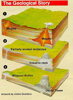
In either case, the tower has been slowly exposed by the subsequent erosion of the surrounding rock. As can be seen by careful observation of the tower, the top of the tower shows the obvious effects of weathering. These effects decrease dramatically as you examine lower heights on the tower sides. This is obvious evidence that the top of the tower has been exposed for much longer than have the lower levels. The diagram below (from the Park Service brochure) shows the way the tower would have appeared over time.
Devils Tower is not an isolated feature. Nearby are found the Missouri Buttes which were formed by the same mechanism.
![]()
Devils Tower - Stories in Stone, Mary Alice Gunderson, High Plains Press, Glendo, WY
Natural History of the Black Hills and Badlands, Sven G. Froiland, The Center for Western Studies, Augustana College, Sioux Falls, SD
See our map and guide reference section for trail maps and other useful information available from Maps.com.
Devils Tower from 200 miles up from Terraserver.
