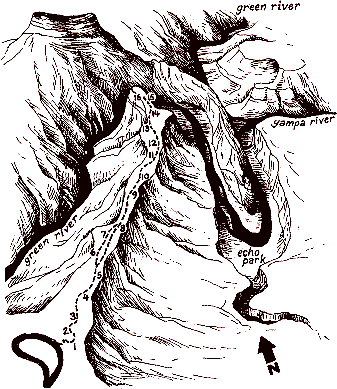
- The canyons you soon will see are the work of flowing water. But here, high above the rivers,
the land is dry, and only water-conserving plants and animals can survive. What do you notice
about the plants? Most have small leaves, often dull-
colored and with fuzzy or waxy surfaces - features which reduc exposure to drying winds,
reflect sunlight, and hold in moisture. The open, even spacing of the trees lessens competition
for groundwater. And though the pinyon pine and juniper may live for hundreds of years, they
rarely grow very large - thus the name "pygmy forest" for this community.
If you are here in spring or early summer, you will find the trailside a wildflower museum,
as bluebells, gilia, paintbrush, and more prepare the seeds for next year's garden. Remember
that many others share the park with you. Please don't pick the flowers or disturb any natural
or historic features. Leave them for the next visitors to see and enjoy.
- Even in death, this old pinyon dominates the scene, and in death it still contributes to the
stream of life. Its wood might provide a home for burrowing insects which in turn are hunted by
woodpeckers, nuthatches, and other birds. Hawks may survey their territory from the high, bare
branches. Bark shed from the limbs slowly decays, returning nutrients to the soil as the rest
of the tree will do when it finally falls.
- What killed the big tree at the last stop? There are several possibilities: insects, disease,
old age, or maybe a porcupine, whose gnawings - yellow or gray scars -
can be seen on many of the tree trunks along here. In winter, when other food is scarce,
"porkies" relish the tender inner bark of the pinyon. Stripping only a little bark, the
porcupine usually does not harm the tree, but if the animal chews all the way around the
trunk, the tree's food and water transport systems are cut off and it will soon die.
- If you were going to homestead, would you do it up here? Probaby not - down by the rivers,
or any other place with a good water supply, would be a much better choice. You may be able
to spot the buildings of the Chew Ranch far below on a small tributary of the Green River
called Pool Creek. This pioneer cattle and sheep ranch, settled near the turn of the century,
is now maintained as an historical site.
Before the Chew family came, Pool Creek was the home of a
colorful character named Pat Lynch, who wandered into the
area in the early 1880s and for 30 years lived a hermit's life in caves and cabins along the
lower Yampa Canyon and Pool Creek. The latter area is often called Pat's Hole after him.
The canyon walls, in fact, have sheltered mankind since ancient times. Drawings pecked into
Pool Creek's cliffs show that the Fremont people, who were hunters and farmers, lived here
nearly 1,000 years ago. They came as others have, lured by the magic of water in a thirsty
land.
- Most of the park's recorded history, sketchy as it Is, concerns Echo Park, at the junction
of the Green and Yampa Rivers. The ruggedness of the land limited exploration by routes other
than the Green. The first man known to have descended that river was William H. Ashley, a fur
trapper. In the week or so that it took his party to pass through these canyons in 1825, the
rapids nearly wiped out his small, hide-covered bullboats, and Ashley no doubt decided against
traveling any further by water.
Nearly half a century passed before the Green was seriously challenged again, this time by
John Wesley Powell in 1869. Despite the loss of a wooden boat in a rapid not far from here -
which they named Disaster Falls - the party followed the Green to its junction with the
Colorado and continued down that river through the Grand Canyon. Echo Park, where they listened
to their voices bouncing off Steamboat Rock, was a welcome rest after days of battling white
water; now it is a peaceful retreat away from the rush of civilization.
-
All this volume of water, confined, as it is, in a narrow channel and rushing with great
velocity, is set eddying and spinning in whirlpools by projecting rocks and short curves,
and the waters waltz their way through the canyon, making their own rippling, rushing, roaring
"music." Thus wrote Powell of Whirlpool Canyon below you.
Listen ... on a calm day you can still hear the distant music of the river.
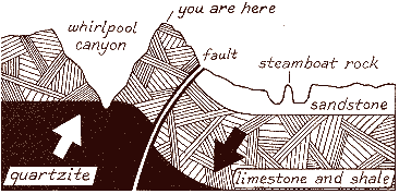
- Did you notice the contrast between Whirlpool Canyon and the Yampa Canyon? Whirlpool's walls
are dark and somber, made up mostly of limestones and shales left by ancient seas. As these
waters retreated, windswept dunes piled up to become the light-colored sandstone of the Yampa's
cliffs and domes - a layer which should lie on top of the Whirlpool Canyon rocks. But when
this area was being uplifted to its present elevation, faulting occurred; the rock layers were
bent and broken as some blocks of land were pushed higher than others. You are standing on the
edge of one of the high blocks from which the sandstone has been eroded away. In the low block
to the east erosion has not progressed so far; the darker rocks are still buried beneath the
sandstone, and the landscape looks much different.
- Can you pick out the course of the Yampa? Its junction with the Green is hidden by Steamboat
Rock, and above that, the river is lost in a maze of sandstone. Such a winding course is more
typical of a slow, sluggish stream flowing across flat land than of a swift, canyon-
cutting river. Some geologists, therefore, have suggested that the Green and Yampa had already
established courses on fairly level land before the region was uplifted; and that the rivers
held course and sliced down through the rocks even as the land rose, thus forming the deep,
winding canyons.
- The reddish rocks alongside the trail are made of a hard sandstone called quartzite which
also appears at the very bottom of Whirlpool Canyon. Did they roll up here from down there?
Not likely - but their rounded shape does suggest that they rolled a long way from somewhere.
The same quartzite forms much of the Uinta Mountains west of here, so these rocks may have been
washed down from the mountains long before the Green River had carved Whirlpool Canyon. Now,
stranded far from their source, they add another element of mystery to a landscape which has
puzzled geologists since Powell's time.
- Take a closer look at those rocks; many of them bear a colorful crust of lichens. Small as
they are, lichens are important pioneers of the plant world, for they can grow on bare rock
where no other plants can. Their secret is that they are actually two plants in one: a fungus
whose sticky filaments anchor it to the rock, and an alga, a "green" plant which uses the
energy of sunlight to produce food from raw elements in the rock. The fungus provides a
foothold and the alga feeds them both. in this harmonious relationship, they also prepare the
way for other plants by breaking down the rock into soil.

- Two kinds of grasses - a native and an intruder - are prominent along this part of the trail.
The native, Indian ricegrass, has a name that hints how it was used. Both the Fremont people
and recent Indians gathered and ground its tiny seeds for mush, cakes and stews. It is also
a valuable food for livestock, deer, and smaller wildlife.
In contrast, cheat grass is almost inedible (except for a brief time in spring) because of
its spiny, irritating seeds. Indeed, these traits enabled it to spread rapidly across the
western range after its accidental introduction from Europe about 1925. Passed over by animals
in favor of more nutritious plants, cheat grass grows undisturbed, and its seeds catch in
fur or clothing which carries them over wide areas.
- Don't build a house where you see trees like this one! The soil on this steep slope tends to
slip downward, and the movement would eventually topple a wall, telephone pole, or other
nonliving object. But a tree, if the tilting is slow enough, keeps trying to straighten up as
it grows, resulting in a curved trunk.
- Trees respond to many environmental influences so subtle that we hardly notice them. Here the trees are taller than the pinyons and junipers, and have spruce-
like needles and dangling, thin scaled cones. These are Douglas firs -
important timber trees in the Pacific Northwest, and common in the high Uinta Mountains, but almost out of their range here. They require a bit more moisture and cooler temperatures than the other trees. These north-facing slopes which receive less sunlight apparently make just enough difference for them to live here.
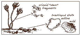
- Back at stop number 7, it was noted that the rocks in Whirlpool Canyon were
formed in ancient seas. How do we know this? First, the rocks are made up
of fine-
grained sediments like the muds usually found on sea bottoms; and second, they
sometimes are embedded with fossils of sea creatures. Look closely at the rocks
beneath your feet. You may be able to spot the clam-like shells of brachiopods,
and pieces of the stems of crinoids or "sea lilies" - actually animals related
to starfish. Though they lived hundreds of millions of years ago - even before
the dinosaurs - their remains help us piece together the jigsaw puzzle of the
past.
- Seashells far above the sea, great blocks of rock bent and broken, deep and
tortuous canyons - was this 1and the site of some great cataclysm? To us,
accustomed as we are to thinking in terms of minutes, hours, and days, the
scene may look like the result of some chaotic upheaval, but it wasn't. All
around us the forces that shaped it are still in action. Rivers deepen their
channels grain by grain; minor earth tremors occur daily in one place or
another; and lands have risen or fallen, slowly but measurably, within historic
times. We measure our history in years, but the Earth measures time in millions
of years -
time enough for each tiny change to be multiplied over and over into a major
change.
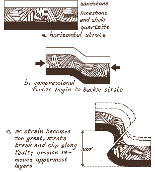
The upturned layers of the Mitten Park Fault below you dramatize such a change.
This is the same fault noted at stop number 7, but here the Green River has
sliced through it to reveal the broken rocks in cross section. Movement along
this fault probably began with the uplifting of the region, and may have
continued off and on almost to the present. Each shift, perhaps accompanied by
what we would call a major earthquake, might have been only a few centimeters,
but over the ages many little shifts added up to a total displacement of about
910 meters (3,000 feet) from one side of the fault to the other.
- Man, too, can alter the land, rarely on such a scale as natural forces, but
much more rapidly. Some years ago, controversy arose over a proposal to build
a dam for water storage and power generation directly below this point at the
head of Whirlpool Canyon. Many people protested that the Green and Yampa Canyons,
already included in Dinosaur National Monument, deserved to remain in their
natural state; that they could serve the nation better as a contrast to
technology than as a contribution to it. The protests were heeded and ultimately
the dam was built at Flaming Gorge, 113 kilometers (70 miles) up the Green
From here.
Even at that distance the dam affects this area. Streamside plants no longer
scoured out by spring floods are spreading. Native fish adapted to muddy water
have retreated to the Yampa because most of the Green's mud now settles behind
the dam. Such changes may or may not seem important, but they illustrate an
important, often forgotten fact: for all our power, we are still subject to
interdependent natural processes. Sometimes we can alter their speed or
substitute one process for another, but every change we make sets in motion
more changes, often far reaching and acting faster than natural systems can
tolerate.
As you retrace your steps along the trail, perhaps you will be reminded of
your links with the Earth and the life it sustains. This is part of the message
of Dinosaur National Monument - a place that can help us understand and live
in harmony with our world.
Published for the benefit of visitors to Dinosaur National Monument,
Colorado - Utah, by Dinosaur Nature Association, P.O. Box 127,
Jensen, Utah 84035, in cooperation with the National Park Service,
U.S. Department of the Interior.
